
Remote Sensing Services Market Size and Forecast (2025–2033), Global and Regional Share, Trends, and Industry Analysis Report Coverage: By Platform (Satellites, UAVs, Others), By Resolution (Spatial, Spectral, Radiometric, Temporal), By End-use (Commercial, Defense), and Geography
2025-12-23
Aerospace & Defense
Ekta Chaurasia (Team Lead)
Description
Remote
Sensing Services Market Overview
The Remote Sensing Services Market is witnessing rapid expansion as organizations increasingly depend on advanced imaging and sensing solutions to monitor assets, assess environmental conditions, enhance security operations, and support data-driven decision-making. Valued at USD 12.3 billion in 2025, the market is projected to reach USD 30.7 billion by 2033, reflecting a robust CAGR of 11.1% during the forecast period. Remote sensing has evolved far beyond traditional satellite imagery, expanding into UAV-based services, hyperspectral imaging, thermal monitoring, radiometric analysis, and AI-powered data processing. This shift reflects organizations’ growing need for precise, real-time geospatial intelligence across sectors such as commercial infrastructure, agriculture, defense, energy, and environmental management.

Increasing digitization, the
proliferation of high-resolution sensors, and greater affordability of
satellite constellations are reshaping how geospatial intelligence is generated
and consumed. Advancements in cloud computing and AI-driven analytics have
significantly increased the usability of remote sensing data, enabling faster
interpretation, automated classification, and predictive modeling for
industries. The commercial segment has become the largest end-use category,
driven by demand for urban planning, location intelligence, natural resource
monitoring, mining, and climate assessment. Simultaneously, miniaturized
satellites, reusable launch systems, and growing access to UAVs are making
remote sensing more accessible to small and mid-sized enterprises.
Remote Sensing Services Market Drivers and
Opportunities
Rising Demand for
High-Resolution Geospatial Intelligence Is Driving Remote Sensing Services
Market Growth
The rapid increase in demand for
high-resolution geospatial intelligence across commercial and governmental
sectors is a key driver for the Remote Sensing Services Market. Industries such
as agriculture, infrastructure, mining, utilities, environmental management,
and insurance increasingly rely on remote sensing data to optimize operations,
monitor assets, and improve decision-making. High-resolution imagery enables
precise mapping, real-time assessment of environmental changes, and accurate
detection of anomaly capabilities that are critical for ensuring operational
efficiency and regulatory compliance. For example, precision agriculture uses
spatial and spectral data to monitor crop health, moisture levels, and pest
activity, enabling farmers to reduce costs and increase yields.
Government agencies and
environmental bodies depend on remote sensing to track deforestation, assess
disaster impact, evaluate water resource distribution, and monitor
climate-related changes. With rising concerns around sustainability, remote
sensing has become a central tool for environmental audits, carbon stock
assessments, and land-use planning. The defense and security sectors are also
major contributors to market growth, utilizing remote sensing for border
surveillance, strategic planning, and threat detection. The ability to capture,
process, and analyze data in near real-time has significantly enhanced response
capabilities for homeland security and emergency services.
Technological advancements such
as the proliferation of small satellites, improved sensor designs,
hyperspectral imaging, and enhanced radiometric accuracy are further
accelerating adoption. The emergence of low-cost commercial satellite
constellations and drone-based platforms has democratized access to
high-quality remote sensing data, reducing dependency on expensive,
government-led space programs. Cloud-based processing, machine learning
algorithms, and data-as-a-service (DaaS) models are making remote sensing more
scalable and user-friendly for businesses. As the volume of geospatial data
continues to increase, the value of high-resolution intelligence will keep
rising, solidifying this trend as a major driver of global market expansion.
Growing Adoption of
UAV-Based Remote Sensing Is Accelerating Market Expansion
The expanding use of unmanned
aerial vehicles (UAVs) for remote sensing applications is another significant
driver shaping the market’s growth trajectory. UAVs, or drones, have
transformed remote sensing by offering flexible, cost-effective, high-frequency
data collection capabilities. Unlike satellites, which have fixed orbital
schedules and limited revisit rates, UAVs can be deployed on demand and
tailored to specific mission requirements. This makes them particularly
valuable for sectors requiring frequent monitoring or localized imaging, such
as construction, energy, utilities, agriculture, and environmental
conservation.
UAV-based remote sensing provides
exceptional spatial resolution, often surpassing that of commercial satellites.
Equipped with multispectral, hyperspectral, LiDAR, and thermal sensors, drones
can generate detailed terrain models, vegetation indices, and structural
assessments with unmatched accuracy. Industries use UAV data for site surveys,
pipeline inspections, asset mapping, power line monitoring, and land
development planning. The rise of smart agriculture has significantly boosted
drone adoption, enabling farmers to detect nutrient deficiencies, irrigation
issues, and disease outbreaks early, thereby improving productivity and
profitability.
Technological advancements in UAV
endurance, sensor miniaturization, autonomous navigation, and data processing
capabilities have expanded their commercial viability. Regulatory frameworks in
major regions such as the U.S., Europe, and the Asia Pacific are evolving to
support wider drone deployment, including beyond visual line of sight (BVLOS)
operations. This regulatory progress is creating new opportunities for
drone-based service providers. The integration of AI and machine learning
further enhances UAV capabilities, allowing automated image classification,
anomaly detection, and predictive insights. As businesses seek more flexible
and cost-efficient alternatives to traditional satellite imaging, UAV-based
remote sensing will continue to play a critical role in driving market growth.
Rising Investments in
Space-Based Imaging and Constellation Expansion Create Significant Market
Opportunities Worldwide
The emergence of low-cost
satellite constellations and increased private-sector investment in space-based
imaging present major growth opportunities for the Remote Sensing Services
Market. Over the past decade, declining launch costs, advancements in small
satellite technology, and rising commercial interest in space exploration have
significantly expanded global satellite deployment. Companies such as Planet
Labs, Maxar Technologies, and BlackSky are launching high-frequency imaging
constellations capable of capturing near-real-time global coverage. These
capabilities support a wide range of applications, including defense
surveillance, economic activity tracking, environmental monitoring, and supply
chain intelligence.
Government agencies across the
U.S., Europe, India, China, and Japan are increasing investments in earth
observation programs and collaborating with private space companies to enhance
regional monitoring capabilities. The development of hyperspectral and SAR
(Synthetic Aperture Radar) satellites expands data diversity, allowing remote
sensing services to penetrate new markets such as disaster response, maritime
surveillance, soil analysis, and climate research. SAR satellites, for example,
can capture imagery through clouds and in darkness, making them indispensable
for all-weather monitoring.
As satellite constellations grow,
so does the demand for advanced data analytics, enabling remote sensing service
providers to offer value-added solutions such as change detection, predictive
modeling, and geospatial AI analysis. The emergence of space-based IoT and
real-time imagery streaming further expands the addressable market. With
increasing emphasis on global environmental transparency, carbon monitoring,
and climate risk assessment, space-based remote sensing will play an essential
role in enabling international sustainability initiatives. These trends
position constellation expansion and space-based imaging investments as one of
the most promising global opportunities for remote sensing service providers.
Remote Sensing Services
Market Scope
|
Report Attributes |
Description |
|
Market Size in 2025 |
USD 12.3 Billion |
|
Market Forecast in 2033 |
USD 30.7 Billion |
|
CAGR % 2025-2033 |
11.1% |
|
Base Year |
2024 |
|
Historic Data |
2020-2024 |
|
Forecast Period |
2025-2033 |
|
Report USP |
Production, Consumption,
Company Share, Company Heatmap, Company Production Capacity, Growth Factors,
and more |
|
Segments Covered |
●
By Platform, By
Resolution, By End-use |
|
Regional Scope |
●
North America ●
Europe ●
APAC ●
Latin America ●
Middle East and
Africa |
|
Country Scope |
1)
U.S. 2)
Canada 3)
Germany 4)
UK 5)
France 6)
Spain 7)
Italy 8)
Switzerland 9)
China 10)
Japan 11)
India 12)
Australia 13)
South Korea 14)
Brazil 15)
Mexico 16)
Argentina 17)
South Africa 18)
Saudi Arabia 19)
UAE |
Remote Sensing Services
Market Report Segmentation Analysis
The global Remote Sensing
Services Market industry analysis is segmented by Platform, by Resolution, by
End-use, and by Region.
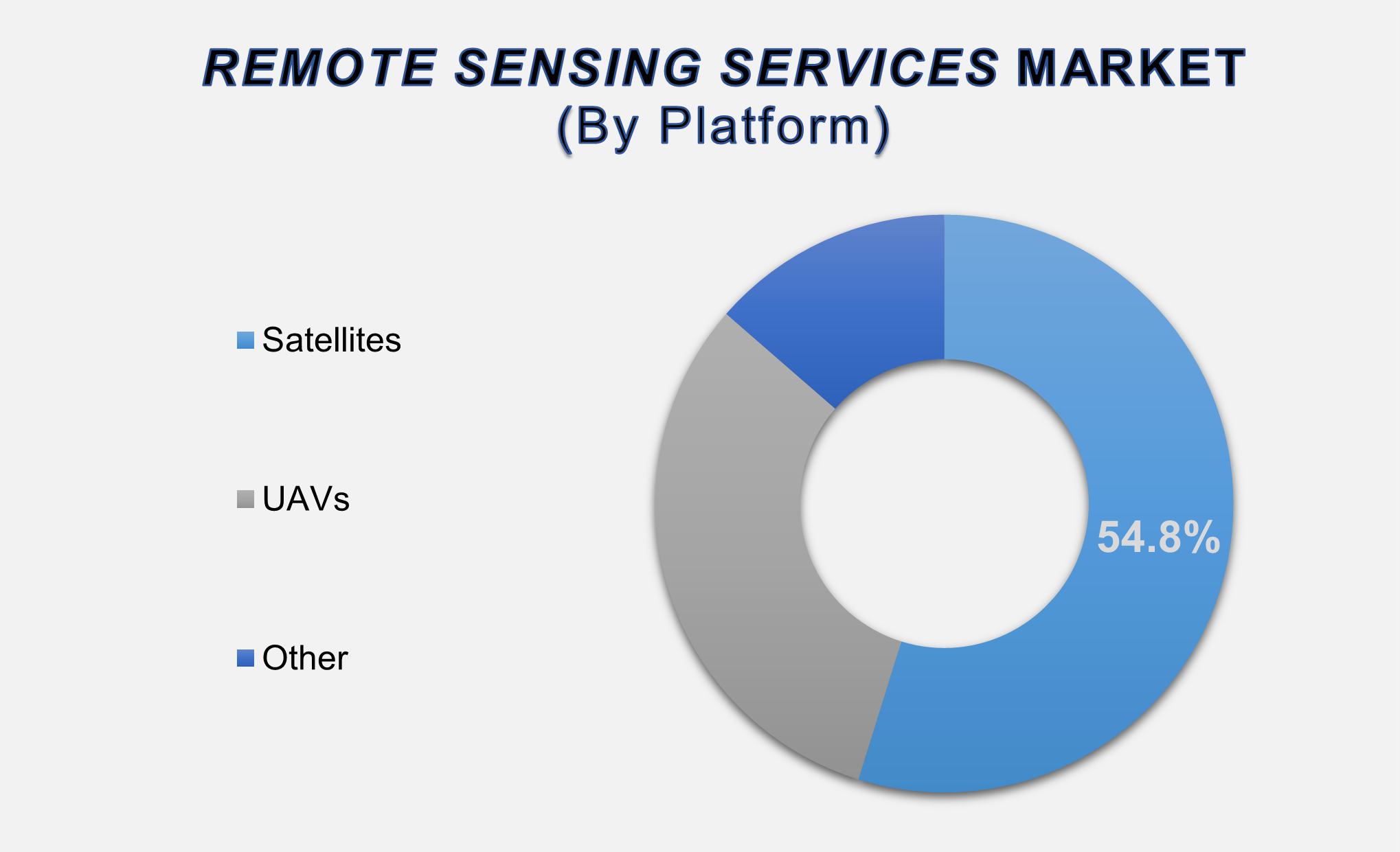
The Satellite Segment
Accounted for the Largest Market Share in the Global Remote Sensing Services
Market
The Satellites segment accounted
for the largest share of the remote sensing services market in 2025,
contributing 54.8% of global revenues. Satellites remain the backbone of the
remote sensing ecosystem by providing consistent, wide-area, and high-frequency
imagery required for strategic surveillance, environmental monitoring, resource
management, and climate analysis. Their ability to capture vast geographical
areas in a single pass makes them indispensable for national agencies, global
corporations, and research organizations. With the rapid expansion of small
satellite constellations and lower launch costs, satellite-based remote sensing
has become more affordable and powerful. The rise of commercial satellite
operators offering near-real-time imaging, high-resolution optical data, and
SAR imagery has transformed the accessibility of geospatial intelligence.
Industries such as agriculture,
infrastructure, and mining utilize satellite imagery for land analysis, crop
monitoring, mineral exploration, and disaster assessment. Defense agencies
depend heavily on satellite surveillance for intelligence gathering, border
monitoring, maritime domain awareness, and tracking geopolitical developments.
Satellite imaging is further strengthened by AI-powered analytics, which allow
automatic detection of changes, movement, or anomalies across large areas. As
demand grows for continuous environmental and security monitoring, and as
global satellite networks continue expanding, this segment will maintain its
dominant market position over the forecast period.
Spatial Resolution
Segment Leads the Global Market Due to High Demand for High-Precision Mapping
and Monitoring
The Spatial resolution segment
leads the resolution-based market, supported by strong demand for
high-precision mapping and surface detail analysis across commercial and
governmental sectors. Spatial resolution focuses on the ability to distinguish
small details on the Earth’s surface, making it the most widely used category
for applications such as urban planning, military surveillance, infrastructure
monitoring, forestry management, and environmental research. As industries seek
more accurate geospatial insights, high-resolution imagery ranging from
sub-meter to multi-meter has become essential for evaluating land use patterns,
detecting structural changes, and assessing ecological conditions.
Advancements in optical sensors,
satellite payload design, and AI-based image enhancement are enabling remote
sensing providers to deliver increasingly detailed spatial data. Additionally,
the integration of spatial data with GIS platforms facilitates advanced
modeling, predictive analysis, and decision support across industries. The
segment also benefits from growing use cases in insurance, real estate
assessment, and supply chain intelligence, where accurate spatial mapping is
critical. As more countries invest in high-resolution earth observation
programs and as commercial satellites continue to achieve improved spatial
capabilities, this segment will remain central to the global remote sensing
services market.
Commercial End-use
Segment Accounted for the Largest Share Due to Expanding Industrial and
Environmental Applications
The Commercial segment accounted
for the largest market share in the Remote Sensing Services Market and is
expected to maintain its leadership position throughout the forecast period.
Growing adoption of geospatial data across commercial industries, including
agriculture, utilities, real estate, construction, mining, transportation, and
environmental services, is driving rapid expansion. Companies increasingly rely
on remote sensing to optimize operations, reduce risk, comply with
environmental regulations, and improve asset management. For instance, mining
operators use remote sensing to track land deformation, assess mineral
potential, and ensure regulatory compliance, while utility providers leverage
imagery for powerline monitoring, vegetation encroachment analysis, and
infrastructure risk assessments.
The segment is further driven by
smart city development, which relies heavily on geospatial intelligence for
urban planning, traffic modeling, and infrastructure development. Remote
sensing also plays a crucial role in environmental impact assessments, carbon
tracking, water resource management, and disaster risk mitigation areas that
are rapidly expanding due to growing climate concerns. The increasing
availability of low-cost satellite imagery, UAV-based surveys, and cloud-based
analytics platforms is making remote sensing accessible to a broader range of
commercial enterprises. As data-driven decision-making becomes integral to
business strategy, the commercial end-use segment will continue dominating
global market revenues.
The following segments are
part of an in-depth analysis of the global Remote Sensing Services Market:
|
Market
Segments |
|
|
By Platform |
●
Satellites ●
UAVs ●
Other |
|
By
Resolution |
●
Spatial ●
Spectral ●
Radiometric ●
Temporal |
|
By End-user |
●
Commercial ●
Defense |
Remote Sensing Services Market Share Analysis by
Region
The North America region
is projected to hold the largest share of the global Remote Sensing Services
Market over the forecast period.
North America dominated the
Remote Sensing Services Market in 2025 with a 45.7% share, driven by
advanced aerospace infrastructure, strong government investment in satellite
programs, and high adoption of geospatial technologies across industries. The
U.S. leads global remote sensing innovation through NASA, NOAA, the Department
of Defense, and a thriving private ecosystem that includes players such as
Maxar Technologies, Planet Labs, and BlackSky. The region's defense sector
represents one of the largest consumers of remote sensing data, using it for
surveillance, reconnaissance, and strategic intelligence. Furthermore, North
America's commercial industries, including agriculture, forestry, utilities,
insurance, and logistics, widely employ satellite and UAV-based sensing to
improve data-driven operational efficiency.
Asia Pacific is expected to grow
at the fastest CAGR during 2025–2033, powered by increasing regional space
activities, expanding satellite programs in India, China, and Japan, and rapid
adoption of remote sensing for smart city development, agriculture optimization,
and resource management. The region’s growing industrialization and investment
in digital infrastructure will further propel remote sensing adoption. Emerging
economies in Southeast Asia, particularly Indonesia, Vietnam, and Malaysia, are
increasing their reliance on geospatial services for land management and
disaster monitoring.
Remote Sensing Services Market Competition
Landscape Analysis
The Remote
Sensing Services Market is moderately consolidated, with global players holding
significant market share and emerging companies innovating in AI-driven
analytics, hyperspectral sensing, and micro-satellite deployment. Leading
companies include Maxar Technologies, Planet Labs, Airbus, L3Harris
Technologies, and MDA, each offering extensive satellite imaging capabilities
and advanced data processing platforms. Newer players such as BlackSky,
Earth-i, and Satellogic are reshaping the competitive landscape with
high-frequency satellite constellations and cost-efficient imaging models.
Global Remote Sensing Services Market Recent
Developments News:
- In June 2022, Planet Labs, Inc., and Bayer AG entered into a contract
for Planet to provide SkySat satellite data and professional services. The
collaboration aims to develop solutions that optimize seed production,
enhance supply chain efficiency, and advance sustainable agricultural practices.
- In April 2022, Maxar
Technologies made a strategic investment in Blackshark.ai, a leading
provider of AI-powered geospatial analytics. This partnership reinforces
Maxar's commitment to advancing its 3D Earth Intelligence portfolio
through innovative, AI-driven data solutions.
The Global Remote Sensing Services Market is
dominated by a few large companies, such as
●
Maxar Technologies
●
Planet Labs
●
Airbus
●
L3Harris Technologies
●
MDA
●
Satellogic
●
URS Corporation
●
Antrix Corporation
●
Mitsubishi Electric
●
Geospatial Corporation
●
Terra Remote Sensing
●
AAM Group
●
Moscow Aerial
Photography
●
Geoserve
●
EagleView
●
Ecopia AI
●
Harris Geospatial
Solutions
●
BlackSky
●
Earth-i
●
ImageSat International
● Other Prominent Players
Frequently Asked Questions
Ekta Chaurasia (Team Lead)
Ekta Chaurasia is a highly experienced Team Lead at M2Square Consultancy with over 7 years of expertise in market research, strategic consulting, competitive benchmarking, and business intelligence solutions. She specializes in ICT, semiconductors & electronics, automotive & transportation, and industrial machinery markets.
She leads end-to-end global research projects focused on market trends, industry analysis, growth forecasting, customer insights, and strategic decision-making. Known for her analytical leadership and industry expertise, Ekta helps businesses uncover growth opportunities, evaluate competitive landscapes, and stay ahead in rapidly evolving markets through accurate and insight-driven research.
1. Global Remote Sensing
Services Market Introduction and Market Overview
1.1.
Objectives
of the Study
1.2.
Global
Remote Sensing Services Market Scope and Market Estimation
1.2.1.Global Remote Sensing
Services Market Overall Market Size (US$ Bn), Market CAGR (%), Market forecast
(2025 - 2033)
1.2.2.Global Remote Sensing
Services Market Revenue Share (%) and Growth Rate (Y-o-Y) from 2020 - 2033
1.3.
Market
Segmentation
1.3.1.Platform of Global Remote
Sensing Services Market
1.3.2.Resolution of Global Remote
Sensing Services Market
1.3.3.End-user of Global Remote
Sensing Services Market
1.3.4.Region of Global Remote
Sensing Services Market
2. Executive
Summary
2.1.
Demand
Side Trends
2.2.
Key
Market Trends
2.3.
Market
Demand (US$ Bn) Analysis 2020 – 2024 and Forecast, 2025 – 2033
2.4.
Demand
and Opportunity Assessment
2.5.
Demand
Supply Scenario
2.6.
Market
Dynamics
2.6.1.Drivers
2.6.2.Limitations
2.6.3.Opportunities
2.6.4.Impact Analysis of Drivers
and Restraints
2.7.
Emerging
Trends for Remote Sensing Services Market
2.8.
Porter’s
Five Forces Analysis
2.9.
PEST
Analysis
2.10.
Key
Regulation
3. Global
Remote Sensing Services Market Estimates
& Historical Trend Analysis (2020 - 2024)
4.
Global Remote Sensing
Services Market Estimates
& Forecast Trend Analysis, by Platform
4.1.
Global
Remote Sensing Services Market Revenue (US$ Bn) Estimates and Forecasts, by Platform,
2020 - 2033
4.1.1.Satellites
4.1.2.UAVs
4.1.3.Other
5.
Global Remote Sensing
Services Market Estimates
& Forecast Trend Analysis, by Resolution
5.1.
Global
Remote Sensing Services Market Revenue (US$ Bn) Estimates and Forecasts, by Resolution,
2020 - 2033
5.1.1.Spatial
5.1.2.Spectral
5.1.3.Radiometric
5.1.4.Temporal
6.
Global Remote Sensing
Services Market Estimates
& Forecast Trend Analysis, by End-user
6.1.
Global
Remote Sensing Services Market Revenue (US$ Bn) Estimates and Forecasts, by End-user,
2020 - 2033
6.1.1.Commercial
6.1.2.Defense
7. Global
Remote Sensing Services Market Estimates
& Forecast Trend Analysis, by region
1.1.
Global
Remote Sensing Services Market Revenue (US$ Bn) Estimates and Forecasts, by
region, 2020 - 2033
1.1.1.North America
1.1.2.Europe
1.1.3.Asia Pacific
1.1.4.Middle East & Africa
1.1.5.Latin America
8. North America Remote
Sensing Services Market: Estimates
& Forecast Trend Analysis
8.1.
North
America Remote Sensing Services Market Assessments & Key Findings
8.1.1.North America Remote
Sensing Services Market Introduction
8.1.2.North America Remote
Sensing Services Market Size Estimates and Forecast (US$ Billion) (2020 - 2033)
8.1.2.1. By Platform
8.1.2.2. By Resolution
8.1.2.3. By End-user
8.1.2.4.
By
Country
8.1.2.4.1.
The
U.S.
8.1.2.4.2.
Canada
9. Europe Remote
Sensing Services Market: Estimates
& Forecast Trend Analysis
9.1.
Europe
Remote Sensing Services Market Assessments & Key Findings
9.1.1.Europe Remote Sensing
Services Market Introduction
9.1.2.Europe Remote Sensing
Services Market Size Estimates and Forecast (US$ Billion) (2020 - 2033)
9.1.2.1. By Platform
9.1.2.2. By Resolution
9.1.2.3. By End-user
9.1.2.4.
By
Country
9.1.2.4.1. Germany
9.1.2.4.2. Italy
9.1.2.4.3. U.K.
9.1.2.4.4. France
9.1.2.4.5. Spain
9.1.2.4.6. Switzerland
9.1.2.4.7.
Rest of Europe
10. Asia Pacific Remote
Sensing Services Market: Estimates
& Forecast Trend Analysis
10.1.
Asia
Pacific Market Assessments & Key Findings
10.1.1.
Asia
Pacific Remote Sensing Services Market Introduction
10.1.2.
Asia
Pacific Remote Sensing Services Market Size Estimates and Forecast (US$ Billion)
(2020 - 2033)
10.1.2.1. By Platform
10.1.2.2. By Resolution
10.1.2.3. By End-user
10.1.2.4.
By
Country
10.1.2.4.1. China
10.1.2.4.2. Japan
10.1.2.4.3. India
10.1.2.4.4. Australia
10.1.2.4.5. South Korea
10.1.2.4.6.
Rest
of Asia Pacific
11. Middle East & Africa Remote
Sensing Services Market: Estimates
& Forecast Trend Analysis
11.1.
Middle
East & Africa Market Assessments & Key Findings
11.1.1.
Middle East & Africa Remote Sensing Services Market
Introduction
11.1.2.
Middle East & Africa Remote Sensing Services Market Size Estimates
and Forecast (US$ Billion) (2020 - 2033)
11.1.2.1. By Platform
11.1.2.2. By Resolution
11.1.2.3. By End-user
11.1.2.4.
By
Country
11.1.2.4.1. South
Africa
11.1.2.4.2. UAE
11.1.2.4.3. Saudi
Arabia
11.1.2.4.4.
Rest of MEA
12. Latin America
Remote Sensing Services Market:
Estimates & Forecast Trend Analysis
12.1.
Latin
America Market Assessments & Key Findings
12.1.1.
Latin
America Remote Sensing Services Market Introduction
12.1.2.
Latin
America Remote Sensing Services Market Size Estimates and Forecast (US$ Billion)
(2020 - 2033)
12.1.2.1. By Platform
12.1.2.2. By Resolution
12.1.2.3. By End-user
12.1.2.4.
By
Country
12.1.2.4.1. Brazil
12.1.2.4.2. Mexico
12.1.2.4.3. Argentina
12.1.2.4.4.
Rest of LATAM
13. Country Wise Market:
Introduction
14.
Competition
Landscape
14.1.
Global
Remote Sensing Services Market Product Mapping
14.2.
Global
Remote Sensing Services Market Concentration Analysis, by Leading Players /
Innovators / Emerging Players / New Entrants
14.3.
Global
Remote Sensing Services Market Tier Structure Analysis
14.4.
Global
Remote Sensing Services Market Concentration & Company Market Shares (%)
Analysis, 2024
15.
Company
Profiles
15.1. Maxar
Technologies
15.1.1.
Company
Overview & Key Stats
15.1.2.
Financial
Performance & KPIs
15.1.3.
Product
Portfolio
15.1.4.
SWOT
Analysis
15.1.5.
Business
Strategy & Recent Developments
* Similar details would be provided for all
the players mentioned below
15.2. Planet Labs
15.3. Airbus
15.4. L3Harris
Technologies
15.5. MDA
15.6. Satellogic
15.7. URS
Corporation
15.8. Antrix
Corporation
15.9. Mitsubishi
Electric
15.10. Geospatial
Corporation
15.11. Terra Remote
Sensing
15.12. AAM Group
15.13. Moscow Aerial
Photography
15.14. Geoserve
15.15. EagleView
15.16. Ecopia AI
15.17. Harris
Geospatial Solutions
15.18. BlackSky
15.19. Earth-i
15.20. ImageSat
International
15.21. Other
Prominent Players
16. Research
Methodology
16.1.
External
Transportations / Databases
16.2.
Internal
Proprietary Database
16.3.
Primary
Research
16.4.
Secondary
Research
16.5.
Assumptions
16.6.
Limitations
16.7.
Report
FAQs
17. Research
Findings & Conclusion
Our Research Methodology
"Insight without rigor is just noise."
We follow a comprehensive, multi-phase research framework designed to deliver accurate, strategic, and decision-ready intelligence. Our process integrates primary and secondary research , both quantitative and qualitative , along with dual modeling techniques ( top-down and bottom-up) and a final layer of validation through our proprietary in-house repository.
PRIMARY RESEARCH
Primary research captures real-time, firsthand insights from the market to understand behaviors, motivations, and emerging trends.
1. Quantitative Primary Research
Objective: Generate statistically significant data directly from market participants.
Approaches:- Structured surveys with customers, distributors, and field agents
- Mobile-based data collection for point-of-sale audits and usage behavior
- Phone-based interviews (CATI) for market sizing and product feedback
- Online polling around industry events and digital campaigns
- Purchase frequency by customer type
- Channel performance across geographies
- Feature demand by application or demographic
2. Qualitative Primary Research
Objective: Explore decision-making drivers, pain points, and market readiness.
Approaches:- In-depth interviews (IDIs) with executives, product managers, and key decision-makers
- Focus groups among end users and early adopters
- Site visits and observational research for consumer products
- Informal field-level discussions for regional and cultural nuances
SECONDARY RESEARCH
This phase helps establish a macro-to-micro understanding of market trends, size, regulation, and competitive dynamics, sourced from credible and public domain information.
1. Quantitative Secondary Research
Objective: Model market value and segment-level forecasts based on published data.
Sources include:- Financial reports and investor summaries
- Government trade data, customs records, and regulatory statistics
- Industry association publications and economic databases
- Channel performance and pricing data from marketplace listings
- Revenue splits, pricing trends, and CAGR estimates
- Supply-side capacity and volume tracking
- Investment analysis and funding benchmarks
2. Qualitative Secondary Research
Objective: Capture strategic direction, innovation signals, and behavioral trends.
Sources include:- Company announcements, roadmaps, and product pipelines
- Publicly available whitepapers, conference abstracts, and academic research
- Regulatory body publications and policy briefs
- Social and media sentiment scanning for early-stage shifts
- Strategic shifts in market positioning
- Unmet needs and white spaces
- Regulatory triggers and compliance impact
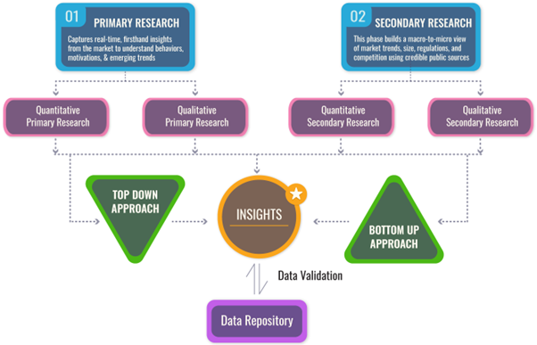
DUAL MODELING: TOP-DOWN + BOTTOM-UP
To ensure robust market estimation, we apply two complementary sizing approaches:
Top-Down Modeling:- Start with broader industry value (e.g., global or regional TAM)
- Apply filters by segment, geography, end-user, or use case
- Adjust with primary insights and validation benchmarks
- Ideal for investor-grade market scans and opportunity mapping
- Aggregate from the ground up using sales volumes, pricing, and unit economics
- Use internal modeling templates aligned with stakeholder data
- Incorporate distributor-level or region-specific inputs
- Most accurate for emerging segments and granular sub-markets
DATA VALIDATION: IN-HOUSE REPOSITORY
We close the loop with proprietary data intelligence built from ongoing projects, industry monitoring, and historical benchmarking. This repository includes:
- Multi-sector market and pricing models
- Key trendlines from past interviews and forecasts
- Benchmarked adoption rates, churn patterns, and ROI indicators
- Industry-specific deviation flags and cross-check logic
- Catches inconsistencies early
- Aligns projections across studies
- Enables consistent, high-trust deliverables